
tradersofhongkong
1950s Original Map of Hanoi City/ Plan de Hanoi - Vietnam
HK $18,000.00
Details
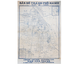
TITLE/CONTENT OF MAP: Bản đồ Thành phố Ha noi. Plan de Hanoi
DATE PRINTED: c. 1950
SIZE: Approx. 75 x 49.5 cm
DETAIL: A beautiful sketch map of Hanoi in Vietnam portraying the mix of French and Vietnamese characters used before independence in 1954. This is a seldom seen locally printed map of Hanoi from the French colonial era published by Librairie - Editions Culturelles
CONDITION: Very Good condition, minor restoration backed on canvas with signs of ageing and a pencil mark by Pont Doumer. Suitable for framing


